River Condition Assessment (RCA) for Biodiversity Net Gain
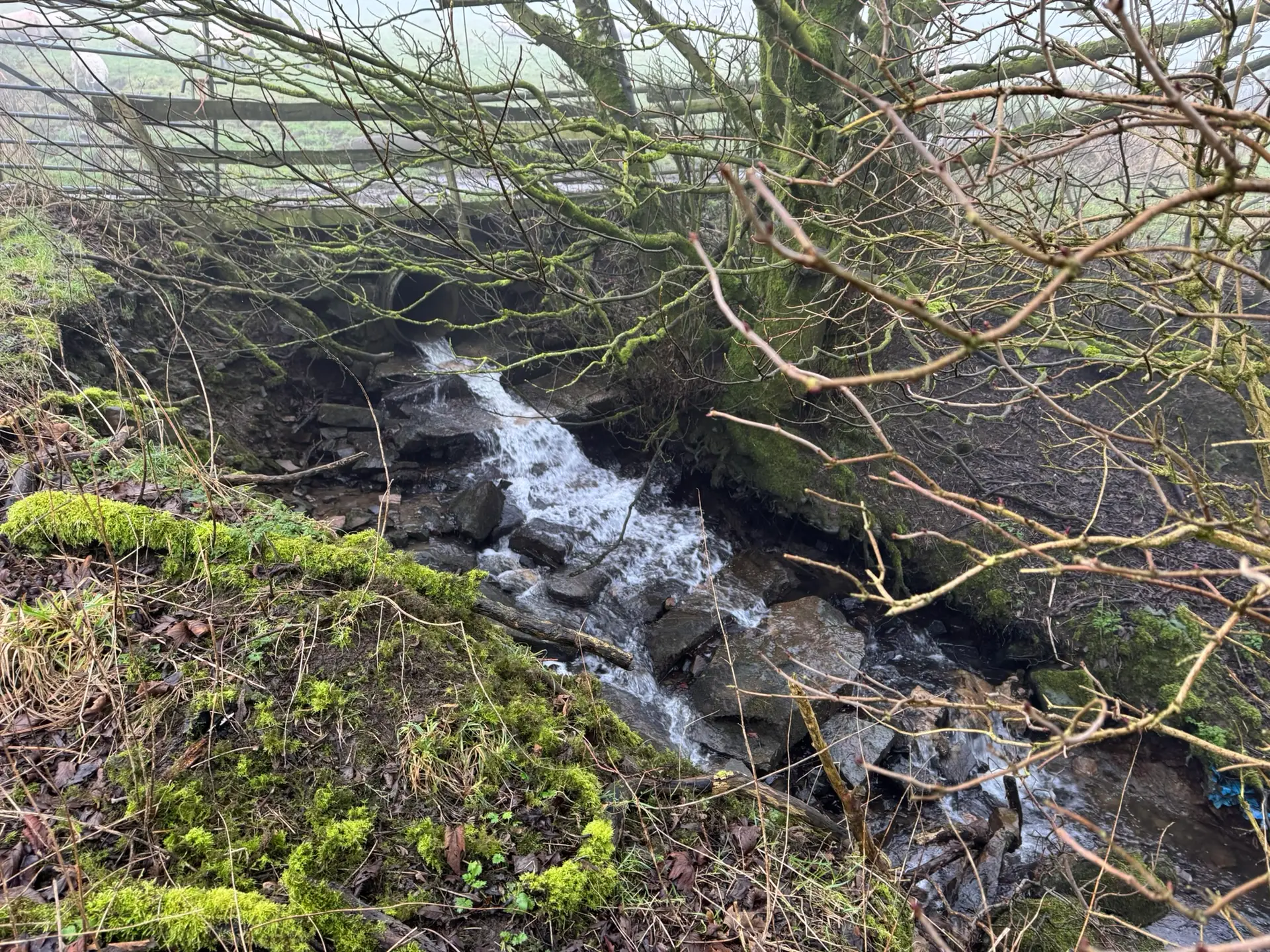
A river condition assessment (RCA) is the statutory method for evaluating the physical condition and ecological quality of rivers, streams and canals within the biodiversity net gain (BNG) framework. It provides the baseline evidence needed to calculate watercourse units in the Statutory Biodiversity Metric and to demonstrate how proposed designs and riparian management will deliver measurable improvements. Without an RCA, it is not possible to evidence river enhancements or secure biodiversity credits linked to watercourses.
An RCA examines the structure of the channel, banks and riparian zone, recording features that influence habitat quality and connectivity. The results are used to score condition, identify risks such as encroachment or erosion, and highlight opportunities for ecological uplift. These findings feed directly into BNG calculations and inform your habitat management and monitoring plan (HMMP), ensuring long-term compliance.
Planning authorities expect a compliant RCA, carried out by a qualified assessor, as part of any application that intersects or affects watercourses. ACP’s ecologists deliver planner-ready RCA reports across England, combining the latest government guidance with recognised field methods such as MoRPh surveys. Our approach ensures transparency, auditability and a clear route from baseline to enhanced river condition.
You can also drop us an email at hello@acp-consultants.com and we’ll get back to you within 24 hours to help with your inquiry!
We follow a simple, transparent process to ensure your project runs smoothly from the very first contact to the final report. Our approach is designed to provide you with clarity at every step, so you’re fully informed and confident in moving forward.
01
Step 1: Request a Quote
Fill out our quick quote form or call us, and our team will provide a free, no-obligation quote, outlining the services tailored to your needs.
02
Step 2: Confirm Your Booking
Once you approve the quote, simply return the booking form. We’ll schedule your survey and ensure all the details are taken care of.
03
Step 3: Receive Your Report
After your survey is completed and payment is received, we’ll promptly issue your survey report, ensuring you get the results as quickly as possible.
What is an RCA and why it matters for watercourse units
A river condition assessment (RCA) is the structured, evidence-based method for assessing the condition of rivers, streams and canals within the biodiversity net gain (BNG) framework. It provides the only accepted route for scoring the baseline and target state of watercourses in the Statutory Biodiversity Metric. Unlike area habitats and hedgerows, which are measured in their own modules, watercourses are assessed through RCA, producing a length-based calculation of watercourse units.
Your RCA establishes the baseline condition score, which directly determines how many watercourse units can be credited to the site. It also sets a realistic target condition, guiding design interventions. Such as bank re-profiling, riparian buffer planting, or in-channel habitat features. By evidencing these improvements, RCA demonstrates measurable ecological uplift moving a section from poor or moderate condition towards fairly good or good.
This process matters because the outcome feeds straight into your BNG calculation. A strong RCA can increase available units and reduce reliance on off-site credits. Also, provide local authority planners with confidence that your development will enhance the local water environment. Conversely, without a robust RCA, watercourse units risk being undervalued or rejected at validation, delaying your application.
When an RCA is required
Under the Statutory Biodiversity Metric, a river condition assessment (RCA) is mandatory for all rivers, streams and canals within or adjoining a development site. These features are assessed through the watercourse module, with scores converted into watercourse units. By contrast, ditches are not subject to RCA; they are assessed using the metric’s separate condition sheets. Culverts are excluded altogether and do not require condition assessment.
Where a site boundary touches the riparian zone, those sections of river or stream must be included in the RCA. The riparian zone is typically defined as 10 metres from the top of each bank for rivers and canals (5 metres for ditches). Condition scoring therefore considers both the channel and the adjacent riparian strip. This ensures that encroachment, bankside vegetation and connectivity are properly accounted for alongside terrestrial habitats assessed in the area and hedgerow modules.
Failing to include an RCA where required is a frequent reason for planning validation delays. A compliant RCA gives local planning authorities confidence that all watercourses within the red line boundary have been properly assessed.
Who can complete an RCA
Current government guidance makes clear that a river condition assessment (RCA) must be completed by a qualified RCA assessor. Competency is not just about fieldwork it requires formal training, knowledge of the MoRPh survey method, and the ability to interpret results in line with the Statutory Biodiversity Metric. Assessors are expected to demonstrate experience, hold relevant ecological or hydrological qualifications, and follow the professional standards set by bodies such as CIEEM and IEMA.
Using an unqualified or inexperienced surveyor can put your planning application at risk. LPAs frequently reject biodiversity submissions where RCA evidence has not been signed off by a competent assessor, leading to delays or additional costs. By contrast, using a qualified assessor provides confidence that condition scores are defensible, that watercourse units have been calculated correctly, and that your submission will withstand audit.
ACP’s team includes fully trained and qualified RCA assessors who deliver compliant, planner-ready outputs nationwide.
Technical methodology: how we deliver a compliant RCA
Our approach to river condition assessment (RCA) is built directly on the Statutory Biodiversity Metric guidance for the watercourse module. We enhance this framework with established best-practice field methods such as MoRPh (Modular River Physical) surveys and a robust evidence pack. The result is a transparent, repeatable method that planning officers can audit with confidence and developers can rely on to secure biodiversity net gain compliance.
Desk study & scoping: hydrology, constraints and ecological indicators
Every RCA begins with a desk-based scoping exercise. We review the water environment context, site constraints and the likely ecological indicators that will drive condition scoring.
- Hydrological assessment covers drainage catchments, baseflow characteristics, floodplain connectivity and the presence of impoundments or culverts. These features directly affect channel form and the river’s ability to support biodiversity.
- Surface water quality is assessed through existing datasets (WFD status reports, Environment Agency data) and local water quality monitoring if available. Indicators such as nutrient concentrations or turbidity help explain observed habitat quality.
- Sediment analysis may be undertaken where fine sediment deposition, embedded gravels or excessive siltation are influencing ecological function. Understanding sediment dynamics also guides options for riverbank stabilization or upstream source control.
This stage provides the foundation for setting realistic target conditions, managing risk, and aligning the RCA with broader environmental compliance assessments in planning applications.
Defining watercourse sections & minimum survey coverage
To make condition scoring meaningful, we divide each watercourse into logical sections. These are based on consistent character, physical interventions, or breaks such as culverts or tributary junctions.
Statutory rules require a minimum of one survey point per section, with survey coverage of at least 20% of the total length. We prioritise points of known intervention such as outfalls, weirs or realignments where ecological impact is greatest. If adjacent sections are found to be of similar character and condition, they can be combined for reporting clarity without compromising transparency.
This structured approach ensures that the RCA evidence is both defensible and representative, while avoiding unnecessary duplication of effort.
Field survey methods: MoRPh, riparian zone & encroachment
Fieldwork is undertaken using MoRPh surveys, which capture the physical features of the channel and riparian corridor. We record bed and bank materials, flow types, in-channel structures, vegetation cover and habitat complexity. This standardised method produces consistent, auditable data and is widely recognised by LPAs and statutory consultees.
The riparian zone is assessed from the bank top:
- 10 metres from each bank for rivers and canals.
- 5 metres for ditches.
- Not applicable for culverts.
Within this zone we document vegetation structure, connectivity, and any encroachments such as fences, walls, tracks or development that reduce ecological function. Both banks are surveyed, and features outside the red line boundary are recorded if they influence condition.
This dual assessment of channel and riparian environment ensures that RCA results reflect the true ecological potential of the watercourse.
Calculating watercourse units in the metric tool
Once surveys are complete, we input each section into the Statutory Biodiversity Metric tool. Sections are marked as retained, enhanced or created. Where only part of a section is improved, it is split into separate rows to avoid partial scoring errors.
The tool calculates watercourse units using section length, RCA condition, riparian attributes and encroachment levels. Evidence including MoRPh forms, photos and diagrams is logged in the User Comments column to support transparency and auditability. This process links field data directly to statutory outputs in a way that LPAs can validate quickly.
Quality assurance, evidence and compliance
Quality assurance is central to our RCA methodology. All condition scores are checked against field notes, photographs and MoRPh records. Results are signed off by a qualified RCA assessor, and a second reviewer is involved where sites are complex or high-risk.
Our reports explicitly reference the Statutory Biodiversity Metric guidance so planning officers can cross-check compliance quickly. This reduces the likelihood of validation queries and provides confidence that watercourse units have been calculated correctly.
In the past year, we’ve delivered over 750 audit-ready reports supporting 400+ projects for developers, planners, and architects nationwide. We put quality over quantity and build lasting relationships based on trust, ensuring your planning applications are backed by robust evidence and delivered on time.
You can also drop us an email at hello@acp-consultants.com and we’ll get back to you within 24 hours to help with your inquiry!
Riparian management & design recommendations
An RCA is not just a baseline assessment — it is also a roadmap for achieving ecological uplift. Based on survey results, ACP provides targeted riparian management recommendations tailored to your site:
- Buffer creation and planting: establishing native shrub and grass buffers along both banks to enhance shading, habitat and habitat connectivity.
- Bank reprofiling and naturalisation: low-impact earthworks, berm creation and riverbank stabilization to improve habitat resilience and reduce erosion.
- In-channel features: introducing riffles, woody material and backwaters to diversify flows and support aquatic species.
- Access and encroachment management: rationalising tracks, fences and informal paths within the riparian zone to minimise disturbance.
- Watershed management strategies: upstream measures (such as SuDS or sediment traps) to reduce fine sediment inputs and improve surface water quality.
- Optional water quality monitoring: periodic checks on nutrients or turbidity to demonstrate ecological improvement alongside condition re-assessments.
These measures provide a clear pathway for moving sections from poor or moderate condition towards fairly good or good, increasing available watercourse units and strengthening your overall BNG case.
Deliverables
When you commission ACP to deliver a river condition assessment (RCA), you receive a comprehensive pack of planner-ready outputs designed to satisfy statutory requirements and reduce planning risk. Each element is structured to support validation and provide practical evidence for your design team.
RCA Report
A full narrative report setting out survey methodology, ecological indicators, MoRPh data, riparian zone mapping and condition scores. This creates a clear, auditable baseline for planners and consultees.
Statutory Biodiversity Metric (SBM) Inputs Pack
Completed rows for each section in the Statutory Biodiversity Metric (SBM), with watercourse units calculations and supporting comments. This ensures your data can be uploaded without re-formatting, saving time at validation.
Riparian Zone Plan
Maps showing 10 m buffers, encroachment features and management priorities. These highlight opportunities for riparian management and a direct link to future uplift.
Design and Management Notes
Targeted advice on measures such as bank re-profiling, buffer planting and channel enhancements. These are presented as recommendations, not obligations, helping your design team identify feasible interventions.
Quality and Competence Statement
Details of the qualified assessor, QA process and compliance with the Statutory Biodiversity Metric User Guide. This gives planning officers confidence in the evidence provided.
Optional Add-Ons
Where requested, ACP can provide repeat RCA surveys, targeted sediment analysis or water quality monitoring to evidence improvements over time. These services are offered separately and only commissioned where they add value to your project.
Deliverables at a glance
Deliverable | Inclusions | Benefit |
RCA Report | Methodology, MoRPh data, photos, evidence log | Clear, auditable baseline |
SBM Inputs | Section rows, watercourse units, comments | Fast validation; fewer LPA queries |
Riparian Plan | Buffer widths, encroachment mapping | Direct link to uplift opportunities |
Design Notes | Practical riparian measures | Guidance for higher condition scores |
QA Statement | Qualified assessor sign-off, QA notes | Planner confidence |
Optional Services | Water quality monitoring, sediment analysis, repeat surveys | Additional evidence if required |
Timelines & costs
For straightforward sites, ACP can usually deliver a draft river condition assessment (RCA) within 5–10 working days of receiving survey access and drawings. This quick turnaround helps avoid delays in planning submissions.
Our pricing is confirmed after a short scoping review and starts from a fixed fee for simple projects. The final cost depends on:
- Scale of watercourses and number of survey sections required.
- Complexity of riparian management needs, such as erosion, encroachment or invasive species.
- Site access and safety considerations, which may affect survey efficiency.
- Additional services requested, such as repeat RCA surveys, sediment analysis or water quality monitoring.
For complex sites with multiple reaches or significant design interventions, we create a milestone timeline aligned with your design team and planning deadlines. This ensures RCA evidence is ready when you need it, integrated with biodiversity gain plans and other environmental assessments.
Why choose ACP for RCA
Qualified assessor expertise
All RCAs are completed and signed off by qualified assessors experienced in the Statutory Biodiversity Metric watercourse module, giving planners confidence in the results.
Guidance-aligned methodology
Our surveys follow government guidance on sectioning, minimum survey coverage and riparian zone widths, ensuring outputs are transparent and compliant.
Design-led advice
We don’t just report scores we connect RCA results to practical design measures such as buffer planting, bank naturalisation and watershed management strategies that improve condition and increase watercourse units.
Planner-ready deliverables
Every RCA is delivered with clear evidence, MoRPh data, photos and environmental compliance assessment notes, helping to reduce validation queries and keep your application moving.
National coverage
From small streams to large canals, ACP delivers RCA services nationwide, supporting developments wherever watercourses intersect your red line boundary.
Frequently Asked Questions About River Condition Assessments
As rivers, streams, and watercourses form critical components of many development sites, accurate assessment of their ecological condition is essential for Biodiversity Net Gain (BNG) compliance. The River Condition Assessment (RCA) follows Natural England’s official methodology to evaluate habitat quality, hydromorphology, and ecological function, forming the basis for calculating river and stream biodiversity units within the statutory BNG metric. This FAQ section explains when an RCA is required, how it differs from other habitat surveys, what data it provides for BNG calculations, and how ACP’s qualified ecologists undertake assessments to ensure full alignment with the latest Defra and Natural England guidance. Whether you’re a developer, planner, or land manager, these insights clarify how river condition results influence design decisions, BNG reporting, and long-term habitat management.
What is a River Condition Assessment and how does it link to BNG?
A river condition assessment (RCA) is the recognised method for evaluating the physical state of rivers, streams and canals in the context of biodiversity net gain (BNG). It measures baseline condition through a structured survey and feeds the results into the Statutory Biodiversity Metric. The outputs generate watercourse units, which are then compared pre-development and post-development to demonstrate uplift. Without an RCA, it is not possible to evidence watercourse improvements in BNG calculations. For developers, this means an RCA is essential if your red line boundary includes or adjoins a watercourse.
Who is allowed to carry out an RCA?
Government guidance specifies that an RCA should be completed by a qualified RCA assessor. This means someone who has undertaken relevant training (often in MoRPh methods), has ecological or hydrological expertise, and is competent to apply the Statutory Biodiversity Metric’s watercourse module. Using an unqualified surveyor risks LPAs questioning or rejecting your submission, which can delay planning or trigger costly re-surveys. By using ACP, you are guaranteed that your RCA will be signed off by a qualified assessor whose credentials are included in your report.
Do ditches and culverts need an RCA?
Not all water features require RCA. Rivers, streams and canals are assessed using RCA. Ditches are included in BNG calculations but are scored using separate condition sheets rather than RCA. Culverts do not require condition assessment at all. It is common for developers to confuse these categories, which can lead to validation issues. ACP clarifies early in the process which features on your site require RCA, which use condition sheets, and which are exempt, ensuring no gaps in your biodiversity evidence.
How much of the watercourse do you survey?
RCA surveys are not required along the entire river length, but the Statutory Biodiversity Metric requires at least one survey point per section, covering 20% of the total length as a minimum. Surveys should also target points of known intervention such as weirs, outfalls or realignments. In practice, ACP often surveys more than the minimum to capture representative data and avoid challenge at validation. Each section is clearly mapped and logged, and evidence such as photographs and MoRPh sheets are submitted with the metric tool entries.
What is MoRPh and why is it used?
MoRPh (Modular River Physical survey) is a field method used to record channel form, bed and bank materials, flow types, instream features and riparian vegetation structure. It provides a consistent, auditable dataset that underpins many RCA calculations. While “morph” is sometimes used informally, MoRPh is the established professional approach recognised in guidance and training. ACP’s surveyors are trained in MoRPh techniques, ensuring that the RCA evidence we provide is robust, standardised and accepted by planning authorities.
How wide is the riparian zone for RCA?
In RCA, the riparian zone is the land adjacent to the watercourse. Government guidance defines this as 10 metres from the top of each bank for rivers and canals, and 5 metres for ditches. Culverts have no riparian zone. Encroachment within this zone such as fences, tracks, or development lowers condition scores. Assessing both banks (even if one lies outside the red line boundary) ensures that results are representative. ACP maps riparian zones, identifies encroachments, and advises on riparian management measures to improve condition.
Is water quality part of RCA?
RCA primarily measures physical and riparian condition, not chemical parameters. However, water quality monitoring (e.g. nutrient levels, turbidity, dissolved oxygen) and sediment analysis can provide important supporting evidence, especially for environmental compliance assessments. These additional checks help explain why certain physical conditions occur and demonstrate improvement after interventions. While not mandatory, ACP can integrate water quality or sediment surveys into your RCA package, giving planners a fuller picture of how your scheme will benefit the river environment.
What design changes can improve scores?
RCA scores can be improved through targeted interventions. These include:
- Native planting and buffer creation along riparian strips.
- Bank re-profiling and riverbank stabilisation to reduce erosion and improve channel form.
- In-channel features such as riffles, woody material or backwaters to diversify flow.
- Watershed management strategies upstream, such as SuDS or sediment traps, to cut fine sediment inputs and enhance surface water quality.
ACP links RCA outputs directly to these design measures, helping your scheme move from poor or moderate condition towards fairly good or good.
How does RCA interact with HMMP and planning conditions?
The RCA provides the baseline and target condition for watercourses. The habitat management and monitoring plan (HMMP) then sets out the 30-year management, monitoring schedule and reporting cadence needed to sustain those gains. Planning authorities often require RCA and HMMP evidence together before discharging biodiversity conditions. By commissioning both through ACP, you get a joined-up package that aligns baseline condition with long-term management commitments.
What do I get from ACP?
ACP delivers a complete compliance pack for your RCA, including a detailed report, SBM inputs with watercourse units, riparian zone mapping, design recommendations, and a quality and competence statement signed by a qualified assessor. Optional add-ons such as repeat surveys, water quality monitoring or sediment analysis are available if needed. This ensures that your planning submission is robust, transparent and ready for validation without unnecessary delays.
How do resource assessment and natural resource management relate to RCA?
A river condition assessment (RCA) focuses on scoring the physical and riparian condition of a watercourse, but it also sits within a wider environmental context. As part of our desk study, we carry out a preliminary resource assessment of existing data, site constraints and survey access to make sure the RCA is efficient and cost-effective. Beyond the survey itself, the findings can also inform broader natural resource management for example, how soil, water and vegetation are managed across a catchment. By linking RCA evidence with responsible natural resource management, developers can demonstrate not only compliance with the Statutory Biodiversity Metric but also a commitment to sustainable, long-term stewardship of rivers and riparian zones.
Government Guidance and Statutory References
- Understanding biodiversity net gain. Guidance on what BNG is and how it affects land managers, developers and local planning authorities. Defra.
- Statutory framework & planning condition – Biodiversity Net Gain under Schedule 7A of the Town and Country Planning Act 1990; statutory regime explained in Planning Practice Guidance (GOV.UK).
- Biodiversity Gain Plan – Must be approved before commencement; Local Planning Authority decision normally within 8 weeks. See Biodiversity Net Gain Guidance (GOV.UK).
- Statutory biodiversity metric – How units are calculated, modules, factors, and guidance on early use. Statutory Metric and User Guide (GOV.UK).
- Condition Sheets & Small Sites Metric (SSM) – Official metric tools and guidance sheets. BNG Metric Tools (GOV.UK).
- Exemptions & de minimis thresholds – Householder, small self-build, and very small impacts where no priority habitat is affected. Exemptions Guidance (GOV.UK) and Defra Environment Blog.
- Off-site register & fee – Natural England guidance on registering biodiversity gain sites, with the current £639 registration fee. Register a Biodiversity Gain Site (GOV.UK).
- NSIPs timing – Government proposals indicate that BNG will apply to Nationally Significant Infrastructure Projects (NSIPs) from May 2026, pending final regulations. Defra Consultation (GOV.UK).
- Creating a Habitat Management & Monitoring Plan (HMMP) – GOV.UK guidance on how to prepare HMMPs, including monitoring and reporting requirements. HMMP Guidance (GOV.UK).
- Natural England HMMP Template (JP058) – Official template, checklist, and monitoring report tools for Habitat Management & Monitoring Plans. Natural England Publications.
- Statutory Biodiversity Metric User Guide (July 2025) – Full guidance on how the statutory metric should be applied, including trading rules and worked examples. User Guide PDF.
- Metric Supporting Documents (JP039) – Includes GIS templates, data standards, and case studies for applying the statutory metric. Natural England Publications.
- Statutory Biodiversity metric user guide.
- Small Site Matric Guidance.
Other Supporting References (Quick Links)
- BNG in Practice Report (2025) – Case studies showing how BNG is being delivered in real projects. Institute of Environmental Sciences.
- Biodiversity Net Gain – Principles and Guidance for UK Construction and Developments. Chartered Institute of Ecology and Environmental Management.
- BNG Research Briefing – This post note outlines the mandatory biodiversity net gain policy introduced in England in 2024 and the risks and challenges for delivering its objectives. UK Parliament.
- Biodiversity net gain: where to start. Natural England.
Recent Google Reviews
Next Steps
- Send us your site boundary and drawings – we scope sections and access.
- Receive a fixed-fee proposal – aligned with statutory RCA requirements.
- Survey and assessment – our qualified assessor completes the RCA fieldwork.
- Planner-ready report and metric inputs – ready for LPA validation.
- Optional support – riparian design, HMMP integration, and ongoing monitoring.
Ready to commission your River Condition Assessment? Contact ACP’s BNG consultants for expert advice and a fixed-fee quote.
Explore Related Biodiversity Net Gain Resources
River Condition Assessments (RCAs) are a key part of measuring habitat quality and hydrological function within the Biodiversity Net Gain (BNG) framework. To understand how RCAs integrate with wider habitat assessments, start with our Biodiversity Net Gain Overview and technical BNG Assessment Guide outlining how aquatic habitats are scored within the Defra metric.
Use the Statutory Biodiversity Metric 4.0 or Small Sites Metric (SSM) to calculate biodiversity units for riparian zones, streams, and ditches. Our Biodiversity Gain Plan (BGP) and Habitat Management and Monitoring Plan (HMMP) provide templates for documenting and maintaining river habitat improvements.
Developers can also reference our BNG Templates & Downloads for standardised RCA forms, estimate implementation costs using the BNG Monitoring Fee Calculator, and review BNG Legislation & Guidance to ensure compliance under the Environment Act 2021. For examples of river and wetland enhancement, see our BNG Case Studies & Portfolio.
You can also drop us an email at hello@acp-consultants.com and we’ll get back to you within 24 hours to help with your inquiry!
- Last Updated:
- July 2026
Disclaimer: Our content is prepared by ACP Consultants’ in-house specialists and is based on current guidance, standards, and best practice in environmental consultancy. While we make every effort to keep information accurate and up to date, it is provided for general guidance only and should not be relied upon as a substitute for professional advice on specific projects. Planning authorities retain final decision-making powers, and requirements may vary between local authorities and over time. ACP Consultants accepts no liability for any loss arising from reliance on this content without obtaining tailored advice for your project.